« PREVIOUS ENTRY
Study: The better you know your spouse, the more likely you are to buy them a gift they hate
NEXT ENTRY »
How YouTube is saving the lost art of guitar wanking
A while ago, New York magazine asked me to write a big feature on the future of New York’s weather. This plunged me hipdeep in all sorts of interesting stuff — from the many naturally-recurring climate cycles that govern our weather, to the predicted effects of global warming. The result was published a few weeks ago, and I’m just now getting around to blogging it!
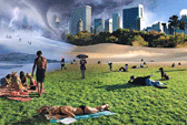
The story — accompanied by that excellent illustration above, created by James Porto — is free at the magazine’s web site, and a permanent copy is also archived below!
The Five-Year Forecast
Unseasonably warm, with freakish snowfalls and chance of cyclone. This winter will be weird, and the weather will keep getting weirder.
by Clive ThompsonThe ash tree vanishes.
The next time you’re in Central Park, go up to Harlem Meer on the north end, then wander westward on the pathway into the heart of the park. After the first sharp turn, look off to the west and you’ll see a thick stand of ash, its rough bark set off by delicate oval leaves. Long before New York existed, the ash thrived in this region, and the city’s settlers used the tree’s dense but springy wood to make everything from church pews to baseball bats. The ash has been here since the beginning.
But its time is about to come to an end. In recent years, foresters have quietly decided not to plant any new ash trees. Why? Because the city is becoming too warm and dry for them, and they’re dying off. Green and white ash, our local varieties, are classified as “hardiness zone three or four,” northern trees that prefer moist, well-drained soil. New York used to be like that, 200 years ago — but the temperature in the past century has risen over two degrees, and it’s getting drier every year. “Last year we had stretches without rain that were practically six weeks long,” says Neil Calvanese, vice-president of operations for the Central Park Conservancy, which maintains the park. And the warmer weather has introduced new wood-eating bugs that afflict the tree. Normally an ash will live 250 years, but this summer Calvanese had to chop down a majestic 130-footer when it stopped thriving. “Ash in the park,” he says, “I really don’t see as having much of a future.”
So he’s decided to let the ash slowly die off. An urban forester has to think decades into the future, and the city’s only going to get hotter and hotter. Instead of the ash, city foresters are starting to plant trees like the persimmon, which thrives in southern climates like Washington’s or even Atlanta’s. Because that’s what the future of New York looks like, weather-wise: There will be fewer and fewer wooden baseball bats and church pews — but plenty of reddish-purple persimmon fruit.
Nor is Calvanese alone in planning for the next 50 years. In September, while unveiling plans for a new city bureau, the Office of Long-term Planning and Sustainability, the mayor pledged to make climate-change issues a priority. It’s not hard to understand why the idea finally occurred to Bloomberg. This summer, the weather was Topic A among New Yorkers, as we sweltered through a record-busting heat wave in July. You could see it in the worried faces of people as they marched miserably down the liquefying sidewalks this summer: Is this it? Has global warming finally arrived? Is this what we’re in for — permanently? The abrupt shift into a spookily mild fall, and especially the freakishly warm last few weeks, has only fanned the conversational fires.
If it seems like the city has been getting hotter for years, it’s not your imagination: Six of the top-ten hottest summers in the city have occurred since 1990. (In fact, we haven’t had a top-ten coolest summer since 1927.) But our summers aren’t the only extreme weather, because our winters have been breaking records in precisely the other direction. The last four winters have all had snowfalls way above average, a string that we haven’t seen since the 1800s. Worse, that record-breaking snow is coming in huge dumps — not a flake in the sky for months and months, then a huge blizzard that sweeps through town, brings the city to a halt, and vanishes a week later.
The weather isn’t just getting harsher: It’s getting weirder. Here’s why.
The little boy comes back.
If you had a satellite’s view of the Earth this summer, you would have noticed something odd happening to the equatorial Pacific: The water was getting warmer.
In June and July, government satellites and thermal buoys that track the heat of the ocean detected a huge mass of bathtub-warm water forming off the coast of Indonesia and Sri Lanka. By August, it had broken loose and begun to migrate across the ocean, headed toward Peru. The normally chilly waters of the Pacific gradually warmed and warmed, until by September the water along the entire equator — a mass twice the size of Europe — was one long ribbon of warm ocean.
It could mean only one thing: El Nino had returned.
El Nimo — Spanish for “the little boy” — is one of the most powerful natural forces that affect global weather. An El Nino event begins when the trade winds in the Pacific break down. Normally they blow east to west, pushing the sun-warmed water on the surface of the Pacific toward Indonesia, where it piles up offshore and makes that nation particularly rainy and wet. Every two to seven years, though, for reasons that are still a bit mysterious, the trade winds falter. As they slacken, the trades’ grip on this pool of warm ocean-surface water slackens, and it begins to spread across the entire Pacific. A really strong El Nino will warm the coast of Peru by as much as eight degrees.
Which is when the weird weather begins — because all that moist, warm water evaporates into the air and produces spectacularly intense rain, winds, and storms. In the U.S., California is the first to get hit: The last big El Nino, in the winter of 1997–98, produced 40-foot-high waves, home- destroying landslides, and the 200-mph Hurricane Linda. The PGA amateur tournament was canceled when golf courses were reduced to mud pits; bewildered California fishermen began catching mahimahi and marlin, because the ocean became so warm that these normally tropical fish swam hundreds of miles north. “A really big El Nino,” says Vern Kousky, a government meteorologist who first announced the El Nino that formed this summer, “has just a huge, huge effect on everything.”
Yet the effect isn’t all bad. Indeed, a strong El Nino makes New York a much nicer place to live — balmier, and with less-violent weather. That’s because as the hot, wet air flows in off the Pacific, it amplifies the speed and intensity of the jet stream, the rivers of fast-moving air that flow toward the east across the country at 20,000 feet. And this more-powerful jet stream, in turn, affects weather all the way to the East Coast. As the jet stream shoots out over the Atlantic, for example, it produces wind shear that “tears hurricanes apart before they can form,” explains Phil Klotzbach, a hurricane predictor with the Tropical Meteorology Project at Colorado State University. Indeed, El Nino is probably the reason this year’s hurricane season has been so much less punishing than last year’s parade of tropical monsters.
What’s more, the amplified jet stream scoops up the milder weather of Washington State and drags it across the country. The current El Nino isn’t yet strong enough to have this effect, but Kousky predicts it could within a few months. “It takes Seattle’s weather,” Kousky says, “and brings it to New York.” During the particularly intense El Nino of 1997–98, not a flake of snow remained on the ground in Manhattan that winter — something that hadn’t happened in more than 100 years. When you’re sitting outside sipping a cappuccino on an unseasonably balmy March afternoon, you’ll have El Nibo to thank.
You can also thank it for a lighter energy bill. Warm winters reduce the demand for oil, and the absence of killer storms keeps Gulf Coast oil-refinery production high. El Nino thus produces cheap oil — indeed, ten years ago, it actually helped cut the price of a barrel in half. This year’s El Nino won’t have quite that powerful a kick, but it’s already been credited with pushing the price of a barrel of oil below $60 for the first time in six months. This slump in prices means spectacularly bad news for the go-go hedge funds that have made their fortunes by betting on wartime oil shortages — such as Amaranth Advisors, the $9 billion fund that lost a mind-bending $6.5 billion in two weeks, then shut down in September. As the weather swings, so swings the energy market.
The fifties are here again.
Digging deeper into the meteorological forces that undergird our weather, I arrange to meet Heidi Cullen — the chief climatologist for the Weather Channel — at a Tribeca cafe on a recent stunning fall day, and she told me about her father. Her family is from Staten Island, and that’s where her father grew up in the fifties. The weather back then was a nonstop carnival of storms and hurricanes. The worst, Hurricane Donna in 1960, terrorized the entire Northeastern Seaboard, and by the time it wound up on Long Island, 364 were dead. So last year, when the tail ends of Katrina and a half-dozen other huge storms lashed New York, Cullen’s father didn’t find it particularly surprising.
“He was like, ‘You guys have no idea what it was like. There were so many big storms and hurricanes back when I was young,’” Cullen says. Only the brave lived on waterfront property.
And, as it turns out, her father’s weather has come back to haunt us: The storms of today eerily resemble those of the fifties. Why? Because of a climate pattern that is set to govern the skies of New York for the next twenty years: the Atlantic Multidecadal Oscillation (AMO).
The AMO is the enormously slow, powerful heartbeat of the Atlantic, a 70-year-long cycle in which the ocean slowly heats up and then cools down again. Scientists began to notice this pattern ten years ago, when they looked back over 150 years of records of the Atlantic’s surface temperature. For a period of 35 years, it would warm up by about one to two degrees; then it would gradually decline until it had cooled by the same amount, over roughly the same time. That difference in temperature doesn’t sound like much, but when you’re talking about a body of water as massive as the Atlantic, a two-degree shift represents an enormous amount of energy. Indeed, hurricanes typically begin forming when ocean water hits 78 degrees Fahrenheit, so every extra degree counts.
The AMO has thus been quietly and secretly influencing New York life for decades — most particularly our housing market. From the mid-sixties to the mid-nineties, the AMO was in its “cold” orientation. Hurricane activity quieted. That’s why the seventies and eighties saw such a housing boom on the coastline of Long Island: The sea was colder but more forgiving, and as the brutal storms of the fifties receded, insurance rates for those houses decreased, making coastal life more affordable.
But in 1995, the AMO started to reverse polarity, and the Atlantic began warming up. Sure enough, our modern plague of hurricanes started right on cue. “People who live around here have a kind of short-term memory,” says Cullen. “With the last few years of storms, they’ve been saying, ‘What the hell is happening?’ But this is exactly what you’d expect with a warmer AMO. We’re back to where they were in the fifties.”
And now the economics of the coastline are reversing themselves. More and more gorgeous waterfront mansions are incurring water damage from the increasingly intense storms. As insurance companies face bigger payouts, they’re starting to pull out. This year, Allstate canceled 30,000 policies in coastal counties of New York, and it plans to limit new business in the region; Nationwide Mutual Insurance has stopped issuing new homeowner policies in parts of Long Island’s storm-prone eastern end. One study suggested that the coastal exposure in the Greater New York area had doubled in the past ten years to $2 trillion in replacement value.
“That’s trillion, with a t,” marvels Michael R. Murray, assistant vice-president for financial analysis at the Insurance Services Office. “We’re talking a massive amount of exposure. We’re talking about something as big as Florida.”
Hitting the funnel.
What’s a region facing trillions in hurricane damage to do? Five years ago, Malcolm Bowman, an oceanography professor at suny Stony Brook, met with the heads of the Port Authority to propose an audacious project: a trio of massive hydraulic gates to protect New York from the huge storm surge in the event a catastrophic hurricane hit the city. Gargantuan gates would be anchored to the floors of three rivers: in the upper East River east of La Guardia, at the Verrazano- Narrows Bridge, and near Perth Amboy, New Jersey, off Staten Island. If a serious hurricane hit the city and ocean waters suddenly began rising, the barriers would close; their tops would stick 25 feet above the water’s surface, preventing the Atlantic from flooding — and destroying — the city.
Building the barriers would be the most ambitious engineering project in the city’s history. The Verrazano gates alone would have to stretch across a mile of open water and reach down 100 feet to the bottom. One design has them looking like saloon doors, swinging shut at the threat of danger. In another design, they lie flat on the bottom and swing upward. In either case, they would cost “at least $10 billion to erect,” guesses Bowman.
Yet the unsettling fact is that we might need them pretty soon. Statistically speaking, Bowman points out, New York is overdue to be hit by an honest-to-goodness cyclone — one that brews in the warm waters down South, then wanders up the Atlantic Coast and slams head-on into Manhattan. One of these monsters hits New York every sixteen to twenty years. We haven’t had one since 1992, precisely fourteen years ago, which makes our continued luck more and more unlikely every year. What’s more, a year from now, when El Nino ends, the AMO should reassert itself as a powerful driver of hurricanes — meaning more wind and water damage is on the way.
New York is in an exquisitely bad position to survive a direct hit. The laws of physics are arrayed against us. The first problem is that while the colder ocean waters off our shores tend to dissipate hurricanes (which is good), the ones that do make it this far north are the ones that move the fastest (bad). When Katrina hit New Orleans, it was traveling at 15 mph. But the one that will eventually hit New York will be traveling at a speed closer to 60 mph. “That means that, effectively, a Category 2 hurricane hits you as hard as a Category 5 hurricane down South,” says Nicholas Coch, a leading expert studying New York hurricanes at the School of Earth and Environmental Sciences of Queens College. “Everyone says, ‘Oh, it’s just a Category 2 storm!’ But when you realize what it’s going to do, your hair stands on end.”
Worse, a hurricane that enters New York Harbor is boxed in. New Jersey and Long Island form an L shape that hurricane experts ominously call “the funnel.” Unlike in Florida, where a hurricane pushes water up the coast, a hurricane that hits the funnel has no place to go. Its energy is concentrated into a tight blast that would hit Manhattan, driving the full force of the harbor’s waters up the East and Hudson rivers. Winds hitting the city’s skyscrapers would experience a “Bernoulli effect” amplifying the wind further, squirting a torrent of moving air into Central Park at tree-shredding intensity. “We’re cursed by our geography,” as Coch puts it. A hurricane that would be relatively mild if it hit anywhere else in the country would thus devastate New York.
In 1893, a Category 3 hurricane did in fact hit the funnel. Water levels rose thirteen feet in a single hour, then kept on climbing until they hit a maximum of 25 feet. If that happened today, transportation would grind to a halt, with both the FDR and the West Side Highway, much of the subway, and all traffic tunnels submerged. All airports would be shut, and, according to one study, upriver water-treatment systems would be contaminated by ocean saltwater.
Perhaps most remarkable, Manhattan would be split into two islands at Canal Street, which is low and would be completely flooded. “The financial district would be entirely cut off,” as one group of Columbia University engineers concluded when it assessed the impact of a direct-hit hurricane. Even higher land uptown would not escape the damage: One computer model of a hurricane estimated that water would surge eighteen feet at West 96th Street.
By the time the storm subsided, the overall cost to New York would be at least $100 billion — 100 times more than the cost of the average storm damage we get in a year now. Even Hurricane Floyd, which swept ashore in September 1999 and was considered a big deal at the time, caused a mere $1 billion in damage.
The only thing that could truly prevent this damage are those gates that Bowman has proposed. But marshaling the political will — to say nothing of the billions of dollars — to build them could be difficult. The initial meeting Bowman had with Port Authority officials back in 2001 seemed promising. “They agreed it was a big issue,” he recalls.
The next week, however, was 9/11. Bowman shrugs. “And you know what happened next.”
A $16 billion bet on a warmer winter.
“One third of our gross domestic product,” declares Colt Heppe, an executive vice-president of ICAP, a new kind of trading desk, “is affected by the weather.” The white-haired, bearlike broker is peering over the shoulder of Peter Rosen, one of his twentysomething traders, as Rosen frantically works a deal via instant messaging. Connecticut-based Tudor Investment Corporation is asking about buying a “weather option” — a financial bet based on the ebb and flow of the weather. Is it going to get warmer? Colder? If your business suffers pain when the mercury unexpectedly plunges or soars, Heppe’s there to offer intriguing financial instruments to hedge the risks.
“Predicting weather is still such a totally inexact science. Kind of like economics,” Heppe jokes. “And that’s why we exist.”
The idea of weather futures has been around for decades, but it developed into an actual market only about ten years ago. The concept is fairly simple. Heppe divides the year into two five-month seasons — a November-to-March winter and a May-to-September summer (April and October act as “shoulder” months bridging the seasons). He figures out the average temperature expected each day for fifteen American cities based on the year-round measurements taken at their airports, and by studying the daily weather predictions issued by U.S. government and European meteorologists.
Then he sells options or puts based on how much people think the actual temperature will deviate from that mean. You could, for example, buy an instrument that pays you a set amount for each degree, per day, that the temperature dips below the expected mean. If it stays warm, you lose; if a cold snap arrives, you win. It is, in essence, a form of weather-based insurance.
“Let’s say you have a coat factory, like Burlington Coat Factory,” Heppe says. “What happens if midway through the winter it’s an El Niño year and it’s very warm, and people do not purchase as many coats?” If it had purchased a put, it could have hedged its risk. In a warm winter, its weather future pays out and diminishes its coat-selling losses; in a cold winter, it loses the money on its future but makes it up on extra coat sales. “It’s just like any natural hedge,” he adds.
Heppe began selling weather futures ten years ago, and his main clients are energy firms, insurance companies, hedge funds, and investment banks, as well as some firms with explicit weather-related risk like ski lodges and resorts. The industry is small — only about $16 billion a year — because the idea still seems a bit weird.
“If you’ve got a business that sells $100 million a year, and you get up at the annual meeting and say, ‘Hey, we should spend $10 million hedging against the risk of the weather,’ it’s hard to convince people,” Heppe admits. “It’s still a niche market. You have to educate people.” But weather, he believes, is becoming a bigger area of public discussion, with the average executive increasingly well informed about it. “Technology is telling us there are recurring patterns we can spot,” he says. “There’s far more data than ever before.” And the weather market isn’t susceptible to being manipulated by powerful financial instruments, because the weather ultimately runs the show — and nobody can control the weather. “You don’t have somebody coming in and single- handedly driving the price of a commodity down to $100,” he says with a laugh.
Has the new El Nino had any effect yet on his business? Heppe shakes his head. After watching a freak blizzard bury Buffalo in mid-October, he’s betting El Niño stays weak for this winter season. But, as he admits, there’s always the outside chance that anything could happen: “It’s the weather.”
Your five-year weather forecast.
Nobody really knows what’ll happen more than a week in advance, of course. But if we assemble these major climatic trends, a rough snapshot of New York’s future begins to emerge.
First off, El Nino will keep our winters reasonably mild and reduce hurricanes in the immediate future, possibly until as late as 2008, because El Ninos usually last for only one or two years.
Meanwhile, the AMO will remain in its warm phase, charging up storms and hurricanes off our shores, for much longer, probably another twenty years. So while El Nino may be driving a temporary reprieve in our nasty weather, once it dissipates, the long-term trend is back to tumultuous hurricane seasons.
The final ingredient in the mix is global warming. In the past century, the average temperature in New York has risen by two degrees, and the trend shows no sign of slowing down. Indeed, the computer models reviewed in the “Metropolitan East Coast Climate Assessment” — a 50-year prediction of New York’s changing climate, developed by NASA and Columbia University — suggest that the city will continue to heat up by as much as one degree by 2010, two degrees by 2020, and accelerate on a gentle curve until we reach as much as nine degrees warmer than now in 2100. It doesn’t particularly matter whether you believe the warming is man-made or a natural cycle (most, but not all, climatologists believe the former). The point is, pumping that much extra energy into the system is bound to have some effect.
The impact on our daily life, though, is the big question. A few degrees of warming won’t turn New York into a Miami-class shirtsleeves town. The effect will be more subtle: Climate scientists suspect that a warmer climate will produce more weather volatility. It’s not that we’ll have more rain overall, more snow overall, or more storms overall. But each event will be more intense than before.
“We’re more likely to get hotter heat waves,” says Mark Cane, a climatologist at Columbia University. “And increased storminess” adds Cullen. Both effects are due to the additional energy that global warming pumps into the “hydrological cycle,” the water and energy that circulates through the atmosphere — and it’s water that creates weather.
Indeed, we may already be seeing these effects. The last four winters have been seemingly pretty dry, but all have been punctuated by out-of-nowhere storms that dump so much snow on the city that the winter overall becomes wetter than normal. A string of hits like that hasn’t happened since the late- nineteenth century, which climatologists find ominous. The virulence of recent hurricanes may also be another early effect. Last fall, a paper in Science pointed out that in the past 35 years, hurricanes have remained steady in sheer numbers — there aren’t more of them. But when they hit, they’re more intense: The number of Category 1 hurricanes has shrunk, while the number of Category 4 and 5 hurricanes has doubled. Another paper in Nature found that hurricanes of the past 30 years have also increased in duration.
As Cullen puts it, global warming “messes with the probabilities. It loads the dice.”
Fifty years from now, the city will be transformed by climate change. Our buildings will be greener, crafted with energy-saving local generators and solar panels; indeed, the latest crop of skyscrapers are already being built that way. Long Island coastline properties will increasingly look like a risky hurricane bet — until everything calms down again in 2020, when the AMO shifts to cool. Spring will move a week or so earlier, as will the pollen season.
And, of course, the thick stands of ash in Central Park will vanish. But other things will emerge. The next time you look to the sky over Jamaica Bay, you may notice a string of long-necked birds flying in a peculiar formation — a perfectly straight line. If you listen carefully, you might hear a cry that sounds like grrrrrr. It’s the glossy ibis, a striking bird with a long, curved beak and a three-foot, shiny, bottle-green wingspan.
Five hundred years ago, local Indians would never have seen one of these birds. They’re a southern species, normally more at home in the everglades of Florida or the Georgian marshes. But the city’s already so much warmer that the Audubon chapter in New York has found that 300 mating pairs are now nesting in Jamaica Bay. “It’s a really amazing sight,” says E. J. McAdams, the group’s former executive director. “They’re really beautiful.”
Enjoy them while you can — because as the climate warms, the sea level off New York is predicted to rise by half a foot in the next fifteen years, swamping the ibis’s new habitat in Jamaica Bay.
The weather giveth, and the weather taketh away.
I'm Clive Thompson, the author of Smarter Than You Think: How Technology is Changing Our Minds for the Better (Penguin Press). You can order the book now at Amazon, Barnes and Noble, Powells, Indiebound, or through your local bookstore! I'm also a contributing writer for the New York Times Magazine and a columnist for Wired magazine. Email is here or ping me via the antiquated form of AOL IM (pomeranian99).
ECHO
Erik Weissengruber
Vespaboy
Terri Senft
Tom Igoe
El Rey Del Art
Morgan Noel
Maura Johnston
Cori Eckert
Heather Gold
Andrew Hearst
Chris Allbritton
Bret Dawson
Michele Tepper
Sharyn November
Gail Jaitin
Barnaby Marshall
Frankly, I'd Rather Not
The Shifted Librarian
Ryan Bigge
Nick Denton
Howard Sherman's Nuggets
Serial Deviant
Ellen McDermott
Jeff Liu
Marc Kelsey
Chris Shieh
Iron Monkey
Diversions
Rob Toole
Donut Rock City
Ross Judson
Idle Words
J-Walk Blog
The Antic Muse
Tribblescape
Little Things
Jeff Heer
Abstract Dynamics
Snark Market
Plastic Bag
Sensory Impact
Incoming Signals
MemeFirst
MemoryCard
Majikthise
Ludonauts
Boing Boing
Slashdot
Atrios
Smart Mobs
Plastic
Ludology.org
The Feature
Gizmodo
game girl
Mindjack
Techdirt Wireless News
Corante Gaming blog
Corante Social Software blog
ECHO
SciTech Daily
Arts and Letters Daily
Textually.org
BlogPulse
Robots.net
Alan Reiter's Wireless Data Weblog
Brad DeLong
Viral Marketing Blog
Gameblogs
Slashdot Games
