« PREVIOUS ENTRY
I am going to buy 2,000 subscriptions to National Geographic
NEXT ENTRY »
Marry an American

So the election’s over, and President Bush is confidently announcing that he’s won a strong mandate — as he put it in his speech yesterday: “I earned capital in the campaign, political capital. And now I intend to spend it.” Meanwhile, the Democrats are morosely pondering the reasons they lost not only the electoral vote but the popular one too, to say nothing of various senate and house seats. And the predictable punditry has begun about “middle America”, “liberal elites,” and the enormous cultural divide in this country.
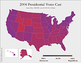
The thing is, the red/blue split is obviously very true in sense — which is the electoral college. With its winner-take-all system, a state either goes Republican or goes Democrat, red or blue, with no phase transition in between. But it’s equally true that this red/blue geographic divide is utterly artificial, because the vote in most states was incredibly, remarkably close. It doesn’t feel close, because the media is obsessed with continually reminding us of red-blue electoral-college map, with its lovely evocation of regional and cultural war: Lookit all that huge, sprawling red space, folks, and those blue states huddled out near the cold water! (That first map above is, by the way, from USA Today.)
But change the map and you change your view of the country. Jeff Culver recently created the amazingly cool second map you see above, which shows the actual division of votes, registered as a mix of red and blue to their proportions. As he shows, the country is in reality mostly “purple”: There nearly as many Democrats as Republicans out in the “heartland” states, just as there are nearly as many Republicans as Democrats in the “liberal” states. These voters probably all massively, heatedly, psychotically disagree with one another about who should be president. But their views are not determined solely by geography.
Call me nuts, but I think one of the biggest challenges American media and punditry has is an interface problem: They are stuck on one dramatic, manichean way of viewing the data. Imagine if TV news and newspapers regularly showed the second map every time they talked about the election. How can you look at that map and talk about some enormous, festering divide in the country? You can’t. As any scientist or graphic artist or video-game player knows, the tools you have for visualizing your situation enormously determine how you think about it.
Sure, merely looking at a purple map wouldn’t change the president’s mind. Like any politician fighting in the electoral college, he only ever cared about tipping enough states over. No president truly fights to win the popular vote. Still, symbols are powerful things. The red/blue map has become the most powerful way of thinking about modern America, yet also the most false.
(Thanks to Boing Boing for this one!)
I'm Clive Thompson, the author of Smarter Than You Think: How Technology is Changing Our Minds for the Better (Penguin Press). You can order the book now at Amazon, Barnes and Noble, Powells, Indiebound, or through your local bookstore! I'm also a contributing writer for the New York Times Magazine and a columnist for Wired magazine. Email is here or ping me via the antiquated form of AOL IM (pomeranian99).
ECHO
Erik Weissengruber
Vespaboy
Terri Senft
Tom Igoe
El Rey Del Art
Morgan Noel
Maura Johnston
Cori Eckert
Heather Gold
Andrew Hearst
Chris Allbritton
Bret Dawson
Michele Tepper
Sharyn November
Gail Jaitin
Barnaby Marshall
Frankly, I'd Rather Not
The Shifted Librarian
Ryan Bigge
Nick Denton
Howard Sherman's Nuggets
Serial Deviant
Ellen McDermott
Jeff Liu
Marc Kelsey
Chris Shieh
Iron Monkey
Diversions
Rob Toole
Donut Rock City
Ross Judson
Idle Words
J-Walk Blog
The Antic Muse
Tribblescape
Little Things
Jeff Heer
Abstract Dynamics
Snark Market
Plastic Bag
Sensory Impact
Incoming Signals
MemeFirst
MemoryCard
Majikthise
Ludonauts
Boing Boing
Slashdot
Atrios
Smart Mobs
Plastic
Ludology.org
The Feature
Gizmodo
game girl
Mindjack
Techdirt Wireless News
Corante Gaming blog
Corante Social Software blog
ECHO
SciTech Daily
Arts and Letters Daily
Textually.org
BlogPulse
Robots.net
Alan Reiter's Wireless Data Weblog
Brad DeLong
Viral Marketing Blog
Gameblogs
Slashdot Games
