« PREVIOUS ENTRY
Fixing the unfixable
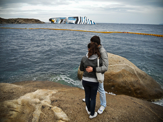
Remember the wreck of the Costa Concordia? The captain ran the ship aground off the Italian island of Giglio, and then was accused of abandoning the vessel before ensuring his passengers got off safely. (They didn’t; tragically, 32 died.) I was recently reading a story in the New York Times about the captain’s court trial and saw photos of the ship, which is still sitting there, lying on its side in the shallow waters off Giglio.
I remember, back when the catastrophe first occurred, being struck by how uncanny — how almost CGI-like — the pictures of the ship appeared. It looks so wrong, lying there sideways in the shallow waters, that I had a sort of odd, disassociative moment that occurs to me with uncomfortable regularity these days: The picture looks like something I’ve seen in a some dystopic video game, a sort of bleak matte-painting backdrop of the world gone wrong. (In the typically bifurcated moral nature of media, you could regard this either as a condemnation of video games — i.e. they’ve trained me to view real-life tragedy as unreal — or an example of their imaginative force: They’re a place you regularly encounter depictions of the terrible.) At any rate, I think what triggers this is the sheer immensity of the ship; it’s totally out of scale, as in that photo above, taken by Luca Di Ciaccio.
But the huge size of the ship made me wonder something else. Is the accident this enormous visible on Google Maps?
Sure enough, it is. Here’s the ship as seen in satellite view:
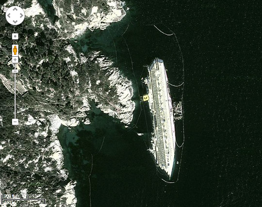
Click here and it’ll take you directly to the precise location on Google Maps. Zoom in and out and check it out. It’s an even more uncanny feeling. One is accustomed to seeing manmade objects via the satellite view in Google Maps; heck, I’ve seen my own house. But one isn’t as accustomed to seeing things that are manmade but aren’t supposed to be there — or at least not in such a wounded, collapsed condition. When I first started looking for the wreck I didn’t know exactly where I was, so I found the town of Giglio, moved over to the water, zoomed in pretty tightly, and began scrolling up the coast. I worried I wasn’t zoomed in close enough to find the ship; it’s difficult to judge precisely how close you are to the ground when you’re doing satellite view. But it turned out I was plenty close, because when I finally found the ship the nose jutted into view so enormously it almost filled my entire screen, and I actually yelped in surprise.
Now I’m wondering: What other accidents are visible in satellite view? Are there any similar catastrophes — collapses, capsizings, etc. — that are out there? Since Google updates its satellite view with some regularity, and since most of these really big accidents take months or years to clean up, there must be tons.
(That terrific photo above is, as noted, by Luca Di Ciaccio and licensed under Creative Commons.)
I'm Clive Thompson, the author of Smarter Than You Think: How Technology is Changing Our Minds for the Better (Penguin Press). You can order the book now at Amazon, Barnes and Noble, Powells, Indiebound, or through your local bookstore! I'm also a contributing writer for the New York Times Magazine and a columnist for Wired magazine. Email is here or ping me via the antiquated form of AOL IM (pomeranian99).
ECHO
Erik Weissengruber
Vespaboy
Terri Senft
Tom Igoe
El Rey Del Art
Morgan Noel
Maura Johnston
Cori Eckert
Heather Gold
Andrew Hearst
Chris Allbritton
Bret Dawson
Michele Tepper
Sharyn November
Gail Jaitin
Barnaby Marshall
Frankly, I'd Rather Not
The Shifted Librarian
Ryan Bigge
Nick Denton
Howard Sherman's Nuggets
Serial Deviant
Ellen McDermott
Jeff Liu
Marc Kelsey
Chris Shieh
Iron Monkey
Diversions
Rob Toole
Donut Rock City
Ross Judson
Idle Words
J-Walk Blog
The Antic Muse
Tribblescape
Little Things
Jeff Heer
Abstract Dynamics
Snark Market
Plastic Bag
Sensory Impact
Incoming Signals
MemeFirst
MemoryCard
Majikthise
Ludonauts
Boing Boing
Slashdot
Atrios
Smart Mobs
Plastic
Ludology.org
The Feature
Gizmodo
game girl
Mindjack
Techdirt Wireless News
Corante Gaming blog
Corante Social Software blog
ECHO
SciTech Daily
Arts and Letters Daily
Textually.org
BlogPulse
Robots.net
Alan Reiter's Wireless Data Weblog
Brad DeLong
Viral Marketing Blog
Gameblogs
Slashdot Games
